


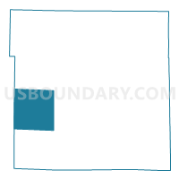
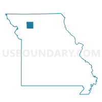
Fairview Voting District, Daviess County, Missouri
About
Outline

Summary
| Unique Area Identifier | 607709 |
| Name | Fairview Voting District |
| County | Daviess County |
| State | Missouri |
| Area (square miles) | 35.98 |
| Land Area (square miles) | 35.71 |
| Water Area (square miles) | 0.27 |
| % of Land Area | 99.24 |
| % of Water Area | 0.76 |
| Latitude of the Internal Point | 39.92352160 |
| Longtitude of the Internal Point | -94.14426100 |
Maps

Graphs
Select a template below for downloading or customizing gragh for Fairview Voting District, Daviess County, Missouri


Neighbors
Neighoring Voting District (by Name) Neighboring Voting District on the Map
- Adams Voting District, DeKalb County, MO
- Altamont Voting District, Daviess County, MO
- Civil Bend Voting District, Daviess County, MO
- Dallas Voting District, DeKalb County, MO
- Wesley Chapel Voting District, Daviess County, MO
- Winston Voting District, Daviess County, MO
Top 10 Neighboring County Subdivision (by Population) Neighboring County Subdivision on the Map
- Liberty township, Daviess County, MO (915)
- Adams township, DeKalb County, MO (709)
- Colfax township, Daviess County, MO (613)
- Jefferson township, Daviess County, MO (506)
- Sheridan township, Daviess County, MO (384)
- Dallas township, DeKalb County, MO (336)
- Marion township, Daviess County, MO (225)
Top 10 Neighboring Place (by Population) Neighboring Place on the Map
Top 10 Neighboring Unified School District (by Population) Neighboring Unified School District on the Map
- Cameron R-I School District, MO (13,070)
- Maysville R-I School District, MO (4,187)
- Gallatin R-V School District, MO (3,183)
- Winston R-VI School District, MO (1,225)
- Pattonsburg R-II School District, MO (1,103)
Top 10 Neighboring State Legislative District Lower Chamber (by Population) Neighboring State Legislative District Lower Chamber on the Map
Top 10 Neighboring State Legislative District Upper Chamber (by Population) Neighboring State Legislative District Upper Chamber on the Map
Top 10 Neighboring 111th Congressional District (by Population) Neighboring 111th Congressional District on the Map
Top 10 Neighboring Census Tract (by Population) Neighboring Census Tract on the Map
- Census Tract 801, DeKalb County, MO (8,900)
- Census Tract 4702, Daviess County, MO (4,990)
- Census Tract 4701, Daviess County, MO (3,443)